|
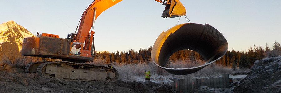
By Robin Mayo On Friday January 15th, Kate Morse of Copper River Watershed Project shared a long term project to better understand the impact of culverts on salmon habitat in the Copper River Watershed and implement on-the-ground projects to improve fish passage. Over 50 people from across the country tuned into the Web-based lecture to learn about the projects. The CRWP convened a Copper River Fish Passage Partnership in 2007, which includes Alaska Department of Transportation, Alaska Department of Fish and Game, US Fish & Wildlife Service, US Bureau of Land Management, Wrangell St. Elias National Park, and U. S. Forest Service. The groups goal was to address issues found in a 2002 study of culverts in the Copper River Valley which found 64% were inadequate, 32% required additional information, and only 4% were considered adequate for fish passage. The partnership took on the daunting task of filling in missing information about hundreds of culverts and their associated habitat, and setting priorities for which ones needed attention the most. A system for measuring, ranking, and ultimately replacing the offenders has been undertaken, with some amazing success stories. Because of the way they restrict streams and change the dynamics, culverts can become a “bottleneck” which affects large areas of natural habitat. As an example, Kate showed a map of the Little Tonsina watershed, upstream from the culvert on the “Burma Pit Road” near mile 74 Richardson Highway. A web of red lines on the map estimated over 70 miles of streams which funnel down into that one crossing. The original culverts were blown out in a high water event in 2006 and the temporary replacements have a multitude of issues. Why do culverts have such a dramatic effect on fish passage? The first thing we are likely to think of is spawning salmon migrating upstream, but it is important to remember that our stream systems are also home to large numbers of juvenile fish. For several years between hatching and heading for the ocean, they travel widely looking for good sources of food. Culverts often constrict the stream flow, causing it to speed up, which leads to deep scour pools downstream. “Perched” culverts have a drop at the lower end creating another obstacle. Unlike natural waterfalls and rapids, there often is no pool upstream of the culvert to allow fish to rest. During normal or low water, the stream may be too shallow in the culvert for fish to traverse, and during high water the stream becomes too fast and turbulent. Poorly designed culverts which are not in line with the steam flow can create all kinds of unintended consequences, including erosion of the roadbed. Kate noted that there are big differences between the unnatural obstacle created by a culvert, and natural features such as beaver dams or fallen trees. Natural obstacles usually spread out and slow the current, and are important because they create shelter for juvenile fish. In contrast, culverts often constrict water to one fast channel. Natural obstacles are part of the ecosystem where the salmon have evolved and thrived, while culverts are a recent addition. The first step in the project is filling in the data gaps. Culverts are assessed for their fish passage qualities, and also the potential for upstream habitat. With hundreds of culverts throughout our road system, this itself has been a massive multi-year effort. They are scored and prioritized, and the partnership works to choose which culverts to move forward on repairing. High priority goes to culverts with poor fish passage, but promising habitat upstream. All data on culverts on fish-bearing streams in the watershed can be viewed at https://copperriver.org/wp-content/uploads/CRWP_CulMapper/. Kate summarized several successful projects, including Goose Meadows on the Copper River Delta, Little Tulsona on the Tok Cutoff, and Chokosna Pond on the McCarthy Road. Design goals for the projects include matching slope and elevation of the stream, aligning with the natural flow direction, completely spanning the stream to avoid constriction, and putting natural substrate in the pipe itself. In before and after photos, the difference is dramatic. The traditional small, round pipes are replaced with huge, flat bottomed culverts which are assembled on site. The unusual shape provides the widest possible stream bed with efficient use of materials and reduced need for excavation. The Little Tonsina project is currently in the design phase, and a two-lane bridge is being planned to replace the culverts. The partnership hopes to complete the design, relocate utilities, and obtain construction bids in 2021, with a goal of constructing the project in the summer of 2022. One of the biggest challenges is lining up funding. For this project, it will come from Alaska Department of Transportation, US Fish and Wildlife Service, the National Oceanic and Atmospheric Administration Restoration Center, US Bureau of Land Management, and the Alaska Sustainable Salmon Fund, reflecting the diverse group of resource managers and stakeholders in the project. This article only skims the surface of what Kate covered in her talk. If you missed it, a recording can be viewed at www.wise-edu.org, and more information on the fish passage projects can be found at the Copper River Watershed Project website, www.copperriver.org. In February, the WISE Science Lectures will feature a two-lecture series titled “Archaeology on the Shores of Ancient Lake Atna.” On Friday February 5 at 5pm, Lee Reininghaus, Archaeologist at Wrangell-St. Elias National Park and Preserve, will give an overview of recent discoveries in the park along the shoreline of Lake Atna, a glacier dammed lake that filled the Copper River Valley thousands of years ago. A week later on Friday, February 12 at 5pm, John T. White, a doctoral student at Texas A&M University, will share “The Excavation of Site NAB-0053,” one of the most interesting sites so far. All of the lectures are being held online, and pre-registration is required. More information and the links to register can be found at www.wise-edu.org. WISE is grateful to partners Prince William Sound College, US Bureau of Land Management, Wrangell-St. Elias National Park, and Copper Country Alliance for assisting with our lecture series. Funding comes from Alyeska Pipeline Service Company and many generous WISE donors. Photo Credit, Copper River Watershed Project
The Little Tonsina culverts at mile 74 Richardson Highway which are scheduled to be replaced with a bridge in 2022. This picture shows how the constriction causes turbulence at high water.
0 Comments
Leave a Reply. |
Who We AreWISEfriends are several writers connected with Wrangell Institute for Science and Environment, a nonprofit organization located in Alaska's Copper River Valley. Most of these articles originally appeared in our local newspaper, the Copper River Record. Archives
August 2021
Categories
All
|
|
WISE is a
501(c)3 nonprofit organization |
Contact Us |


 RSS Feed
