
|
By Robin Mayo On Friday January 15th, Kate Morse of Copper River Watershed Project shared a long term project to better understand the impact of culverts on salmon habitat in the Copper River Watershed and implement on-the-ground projects to improve fish passage. Over 50 people from across the country tuned into the Web-based lecture to learn about the projects. The CRWP convened a Copper River Fish Passage Partnership in 2007, which includes Alaska Department of Transportation, Alaska Department of Fish and Game, US Fish & Wildlife Service, US Bureau of Land Management, Wrangell St. Elias National Park, and U. S. Forest Service. The groups goal was to address issues found in a 2002 study of culverts in the Copper River Valley which found 64% were inadequate, 32% required additional information, and only 4% were considered adequate for fish passage. The partnership took on the daunting task of filling in missing information about hundreds of culverts and their associated habitat, and setting priorities for which ones needed attention the most. A system for measuring, ranking, and ultimately replacing the offenders has been undertaken, with some amazing success stories. Because of the way they restrict streams and change the dynamics, culverts can become a “bottleneck” which affects large areas of natural habitat. As an example, Kate showed a map of the Little Tonsina watershed, upstream from the culvert on the “Burma Pit Road” near mile 74 Richardson Highway. A web of red lines on the map estimated over 70 miles of streams which funnel down into that one crossing. The original culverts were blown out in a high water event in 2006 and the temporary replacements have a multitude of issues. Why do culverts have such a dramatic effect on fish passage? The first thing we are likely to think of is spawning salmon migrating upstream, but it is important to remember that our stream systems are also home to large numbers of juvenile fish. For several years between hatching and heading for the ocean, they travel widely looking for good sources of food. Culverts often constrict the stream flow, causing it to speed up, which leads to deep scour pools downstream. “Perched” culverts have a drop at the lower end creating another obstacle. Unlike natural waterfalls and rapids, there often is no pool upstream of the culvert to allow fish to rest. During normal or low water, the stream may be too shallow in the culvert for fish to traverse, and during high water the stream becomes too fast and turbulent. Poorly designed culverts which are not in line with the steam flow can create all kinds of unintended consequences, including erosion of the roadbed. Kate noted that there are big differences between the unnatural obstacle created by a culvert, and natural features such as beaver dams or fallen trees. Natural obstacles usually spread out and slow the current, and are important because they create shelter for juvenile fish. In contrast, culverts often constrict water to one fast channel. Natural obstacles are part of the ecosystem where the salmon have evolved and thrived, while culverts are a recent addition. The first step in the project is filling in the data gaps. Culverts are assessed for their fish passage qualities, and also the potential for upstream habitat. With hundreds of culverts throughout our road system, this itself has been a massive multi-year effort. They are scored and prioritized, and the partnership works to choose which culverts to move forward on repairing. High priority goes to culverts with poor fish passage, but promising habitat upstream. All data on culverts on fish-bearing streams in the watershed can be viewed at https://copperriver.org/wp-content/uploads/CRWP_CulMapper/. Kate summarized several successful projects, including Goose Meadows on the Copper River Delta, Little Tulsona on the Tok Cutoff, and Chokosna Pond on the McCarthy Road. Design goals for the projects include matching slope and elevation of the stream, aligning with the natural flow direction, completely spanning the stream to avoid constriction, and putting natural substrate in the pipe itself. In before and after photos, the difference is dramatic. The traditional small, round pipes are replaced with huge, flat bottomed culverts which are assembled on site. The unusual shape provides the widest possible stream bed with efficient use of materials and reduced need for excavation. The Little Tonsina project is currently in the design phase, and a two-lane bridge is being planned to replace the culverts. The partnership hopes to complete the design, relocate utilities, and obtain construction bids in 2021, with a goal of constructing the project in the summer of 2022. One of the biggest challenges is lining up funding. For this project, it will come from Alaska Department of Transportation, US Fish and Wildlife Service, the National Oceanic and Atmospheric Administration Restoration Center, US Bureau of Land Management, and the Alaska Sustainable Salmon Fund, reflecting the diverse group of resource managers and stakeholders in the project. This article only skims the surface of what Kate covered in her talk. If you missed it, a recording can be viewed at www.wise-edu.org, and more information on the fish passage projects can be found at the Copper River Watershed Project website, www.copperriver.org. In February, the WISE Science Lectures will feature a two-lecture series titled “Archaeology on the Shores of Ancient Lake Atna.” On Friday February 5 at 5pm, Lee Reininghaus, Archaeologist at Wrangell-St. Elias National Park and Preserve, will give an overview of recent discoveries in the park along the shoreline of Lake Atna, a glacier dammed lake that filled the Copper River Valley thousands of years ago. A week later on Friday, February 12 at 5pm, John T. White, a doctoral student at Texas A&M University, will share “The Excavation of Site NAB-0053,” one of the most interesting sites so far. All of the lectures are being held online, and pre-registration is required. More information and the links to register can be found at www.wise-edu.org. WISE is grateful to partners Prince William Sound College, US Bureau of Land Management, Wrangell-St. Elias National Park, and Copper Country Alliance for assisting with our lecture series. Funding comes from Alyeska Pipeline Service Company and many generous WISE donors. 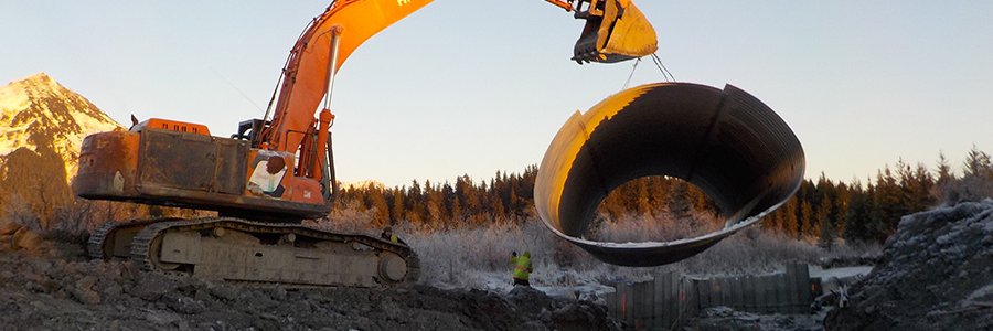 Photo Credit, Copper River Watershed Project
The Little Tonsina culverts at mile 74 Richardson Highway which are scheduled to be replaced with a bridge in 2022. This picture shows how the constriction causes turbulence at high water.
0 Comments
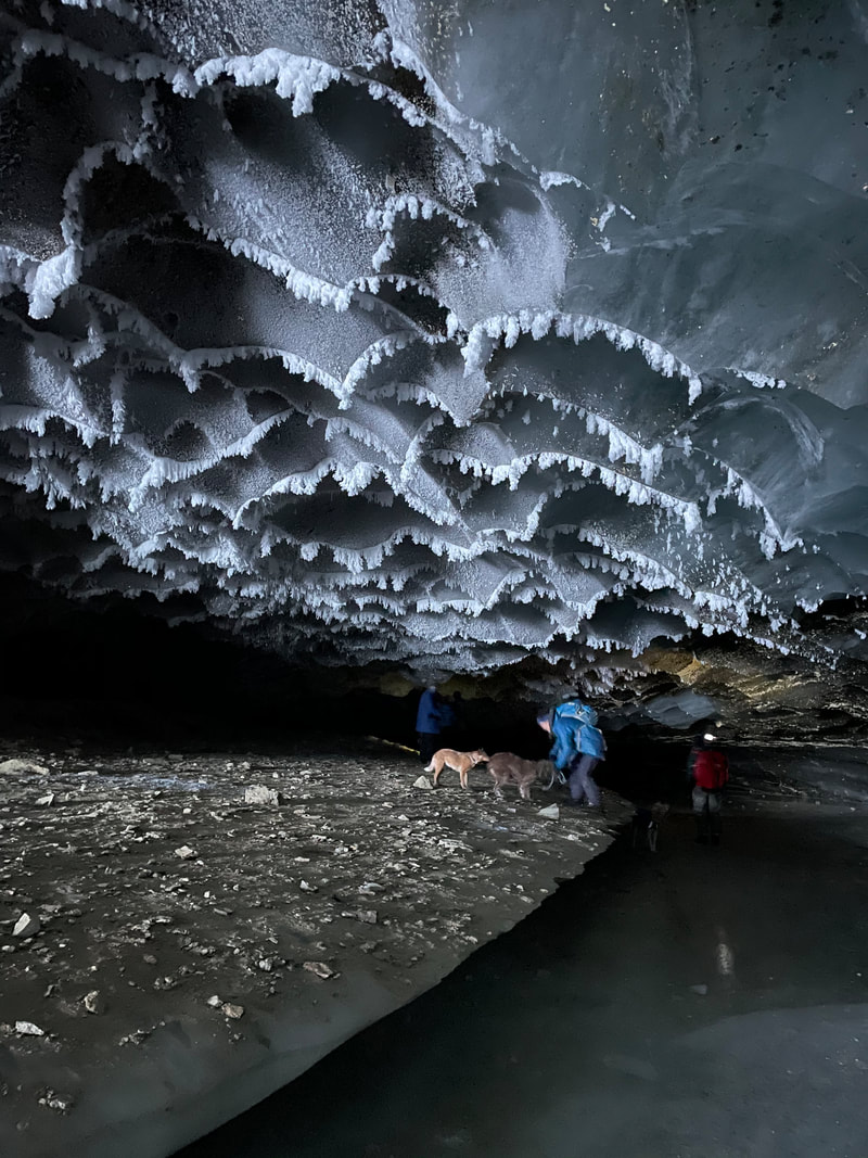
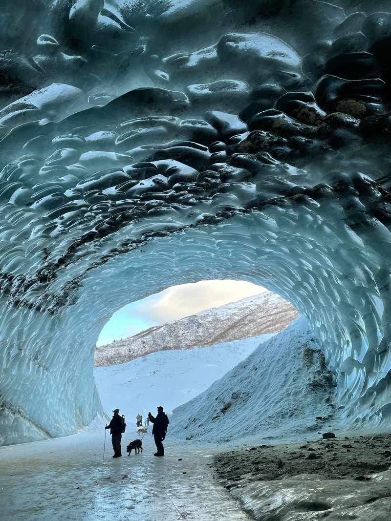
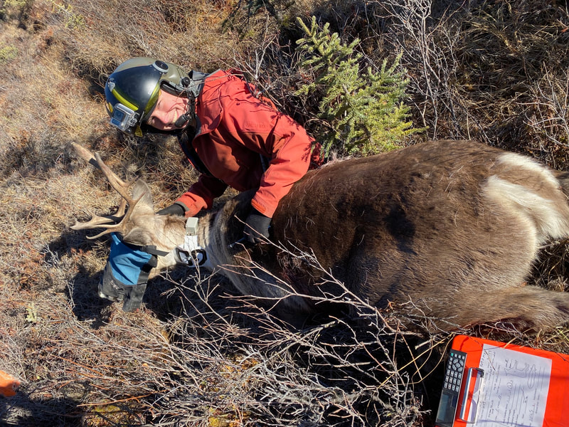
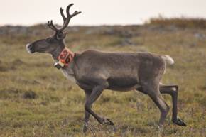
By Robin Mayo If you are looking for an adventure that is within reach and family friendly, I highly recommend planning a trip to the Castner Glacier Ice Cave. With a two-hour drive from Glennallen and a one-mile walk, you can access a truly breathtaking experience. The cave is approximately 50 feet wide and 40 feet tall at the entrance, and tapers as it goes back about 200 feet into the glacier. (Note: these numbers are pure estimate, I’m wishing I’d done some pacing!) Part of the floor is smooth ice, and the rest a mix of ice, dirt and rocks. We followed the curving cave until it was pitch dark, and the ceiling was too low for walking. Best of all, it seems to be pretty stable in the winter, so it can be explored in relative safety if basic precautions are followed. One of the surprises for me was how many other people were there! On a December weekend we saw about 40 other people on the trails and at the cave, and I’d estimate there were over 100 on a weekday during the holiday break. It was fun to see so many people respectfully sharing the trails and enjoying themselves, but if you want to experience the place in solitude you may need to choose a weekday and/or be prepared to wait patiently. Near the entrance, the ice was shining, with a unique scalloped texture and run through with ribbons of gravel reminiscent of polished marble. Further in, the ceiling is festooned with ice crystals, some reminding us of perching butterflies, and others needle-sharp or feathery. We could hear water gurgling beneath the ice, and a few damp spots reminded us to be very cautious. The cave is accessed from the Castner Creek Bridge at mile 217.3 Richardson Highway, about 20 miles north of Summit Lake. Two trails go to the east up the creek, one from the parking area at the southeast corner, and the other about 100 feet north of the bridge. DOT has made crude but usable parking areas around the bridge. At my last visit in early January both trails were beautifully hard packed and easily walked. About halfway to the cave they come together on the creek. The trails are mostly similar and both well used, but the southern one included a steep 15 foot drop down to the creek, and the northern one is partly in the woods so more sheltered. If you go, I’d recommend checking the weather for Delta Junction and Paxson to get some idea of conditions. This is a notoriously windy area, so come prepared with extra layers for the wind chill. I’d also recommend having snowshoes or skiis available in case the trail is blown in, which was the case on my first visit in December. Although this is a relatively easy adventure, please have safety in mind. There was no cell phone coverage, so someone should know where you are and when you plan to return. Much of the trail is on an active creek, so give open leads a wide berth and be alert for new holes, which could open up even in the trail. At the cave, you may want walking sticks and/or cleats for your boots to make it safer to walk on the ice. There are rocks suspended in the ice which could fall, especially as the weather gets warmer. And towards the back of the cave, we could hear water and saw evidence of recently overflow and seepage, so be very cautious on the ice. If you want to explore the very back of the cave you will need a flashlight or headlamp, which we also found very useful for getting good photographs. Families with young children might want to bring along a sled for taxi service for tired little explorers. Although this place feels like the middle of nowhere, it is important to be prepared for and considerate of other visitors. The parking areas are small, but workable if people don’t hog space, and are careful not to block other vehicles. Lots of dogs were enjoying the adventure, but everyone had leashes and was keeping their pet close, which I appreciated. The walk is so short a snowmachine would be needed only for someone who couldn’t make it otherwise. If you do bring your machine please yield to foot traffic, who have the right of way. In a place like this, it is also courteous to stay on the trail as much as possible, to keep the views pristine and also avoid creating lots of side trails which make the main trail hard to follow. I wish I knew more about the history and geology of this cave, which appears to be formed from the combination of the stream running underneath, and the warm summer air melting out the entrance. It sounds like it has been there for quite a few years. The mouth of the cave faces roughly northward, which means it is spared long exposure to the sun which would speed up the melting. WISE is considering leading some hikes there later in the winter, if you are interested please let me know and I’ll fill you in on details, or keep an eye on the WISE FB page and website. By Robin Mayo On December 18 WISE and our partners held our first Science Lecture of the season, a talk by Alaska Department of Fish and Game Area Wildlife Biologist Heidi Hatcher on the Nelchina Caribou Herd. The talk was held online, which opened it up to people from out of the local area. Interest was huge, with well over 100 people registering, and 96 households logging in to listen. We started the evening with a look back at the long history between humans and the members of the deer family known as caribou in North America, and reindeer in Europe and Asia. As well as being an important game species for thousands of years, they have been domesticated and used for a wide variety of purposes including dairy production and beasts of burden, a tradition that still continues. They also held a strong place in mythology, which help explain how we ended up with reindeer pulling Santa’s sleigh. Even Rudolph the Red Nosed Reindeer has an explanation in biology, as their noses have increased blood flow in the winter to keep warm. In Alaska there are 32 caribou herds, generally named based on their calving areas. The Nelchina Herd is fairly unique in that it usually spends spring, summer, and fall in relatively accessible areas. The herd is in high demand for hunting, and since the 1990’s has been what Heidi described as “a notorious experiment in Caribou management.” As she reviewed the history and current status, Heidi wryly observed “One thing that’s certain with caribou is that if you try to generalize them they will inevitably find a way to defy the rules that you outline.” There is a basic understanding of the status of the herd since the 1860’s based on oral history and observations. The first scientific census was in 1948, when there were roughly 10,000 caribou. Regular counts began in the 1950’s and continue to this day. Throughout that time there have been drastic fluctuations in the population, range, and average distances travelled. Count estimates range from 10,000 to over 70,000 animals, and the herd has travelled as far as Dawson City, Yukon Territory. The current management objectives for the herd are to keep it large enough to provide for hunting, but below the carrying capacity of the range. This is challenging for a number of reasons, including the difficulty of getting an accurate count every year, changes in range, switching between herds, and the challenges of “managing” the herd of humans who are hunting. In the early 80’s an objective of 20,000 adult animals was set, and that number was adjusted over the years. Currently the population goal is 35,000 to 45,000 total animals. Factors including herd size, productivity, and harvestable surplus are used to determine the harvest goals for the next year’s hunting season. ADF&G uses several methods to gather information on the herd. Every October they put VHS radio collars on 20 female calves. When the animals are captured and drugged for collaring they also collect measurements and biological samples. Weighing the calves helps determine the general status of the nutrition available on the range , which affects the health of the herd. They also have 40-60 GPS satellite collars on animals in the herd which can be tracked more easily from the office. These collars help them determine location and mortality for the herd. Population counts are also undertaken every summer, but conditions don’t always cooperate. Teams of counters fly a grid of the area in Super Cubs, and depending on the concentration of animals, they are also sometimes able to use special planes equipped with GPS linked high resolution cameras. Heidi shared an excellent video, Counting Caribou, on the annual counts which can be seen at: https://vimeo.com/471257951 The researchers also conduct surveys to estimate the number of males, females, and calves in the herd to determine the composition. All of these numbers are combined to come up with population estimates for the year. This information is used by ADF&G to determine hunt quotas to try and achieve a harvest that reaches their objectives. They use these quotas, as well as hunt extensions, emergency closures, and winter openings to help reach the desired harvest rate and gender ratios. Estimating that a hunter gets 60 to 100 pounds of meat from an animal, each year the Nelchina Caribou Herd produces about 240,000 pounds of food for Alaskans while maintaining a fairly stable population. It is a challenge to summarize the huge amounts of information Heidi shared in her talk and the question and answer session which followed. The full recording of the December 18th talk can be accessed at the WISE website: www.wise-edu.org. WISE has more Science Lectures scheduled for January and February, including learning about Copper River Watershed Project’s Salmon Habitat Restoration Projects with Kate Morse (Noon on Friday, January 15) and two lectures exploring Archaeology on the Shorelines of Ancient Lake Atna on February 5th and 12th. To register for any of these online events, you can find registration links on the WISE website. They will also be recorded if you’d like to watch them at a latertime. A huge Thank You to Prince William Sound College for providing technical assistance for these lectures, and to our funding partner Alyeska Pipeline Service Company for financial support. Copper Country Alliance and Wrangell-St. Elias National Park and Preserve are also program partners. ADF&G Photo. Heidi working with a sedated caribou
|
Who We AreWISEfriends are several writers connected with Wrangell Institute for Science and Environment, a nonprofit organization located in Alaska's Copper River Valley. Most of these articles originally appeared in our local newspaper, the Copper River Record. Archives
August 2021
Categories
All
|
 RSS Feed

|
WISE is a
501(c)3 nonprofit organization |
Contact Us |