
|
Copper River Record August 2017
By Robin Mayo For ten days in July, high school students from the Copper Basin and Cordova participated in the Copper River Stewardship Program, an intensive exploration of the watershed which gives the students a chance to learn about the diverse communities and ecosystems that make up the region. The theme of the program this year was “Helping youth find their voices,” with daily writing and reflection projects. Alex VanWyhe was our guest educator, leading the humanities portion of the program. Ten years ago, Alex was a student in WISE’s Watershed Leadership Program, a precursor to the Copper River Stewardship Program. He now teaches English at Haines High School, and his participation in this year’s program brought it full circle. The ten students were chosen through a competitive process, and will earn high school credit for completing the program and doing final projects. This winter we will plan an evening for them to share their projects with the community. The students paddled canoes up and down Alaganik Slough to a US Forest Service camp on the Copper River Delta, where we helped maintain artificial nest islands for Dusky Canada Geese. We took a long ferry ride through Prince William Sound with a chance to learn more about the Exxon Valdez Oil Spill. Then we joined a BLM Glennallen Field Office river crew for a raft trip down the Gulkana River from Paxson Lake to Sourdough. Early in the trip, the students learned to write Haiku, a Japanese poetry form with a simple 5-7-5 syllable count. Alex encouraged the students to write throughout the trip, with the incentive of a poetry competition and prizes on the last day. Students and staff alike tapped out rhythms on canoe paddles, tent walls, and raft oars for the rest of the trip, and scribbled our words into “Rite in the Rain” notebooks. On the final evening, the stewards gathered around a fire and shared their best efforts. The Copper River Stewardship Program is organized by WISE, Prince William Sound Science Center, Copper River Watershed Project, US Bureau of Land Management, US Forest Service, and Wrangell-St. Elias National Park. This year’s program was made possible with funding from Prince William Sound Regional Citizens Advisory Council, Alyeska Pipeline Service Company, and BLM. Patiently walking Throughout the day we slowly went Through Dusky Bay Joseph Hardy Cool liquid glistens In the morning sun as waves Spread like wildfires Kaleb Carillo Spa-loosh we tramp on Through the bogs squishy terrain And the sound of life Izaac Nelson Team Dusky works hard Viciously ripping Sweet Gale From Shrek’s musky swamp Jessie Hale Once used boats now tied Waters change behind our backs We wander onward Boots stomp natures path The scenic view is foreign We wander onward Artificial land We are tasked with maintenance We have met our task Will Hand Invisible from view Nestled between the shrubs Protect the nests Ethan Beckett We slide upon rocks Struggling from their heavy grasp Worn rafts now flow free Will Hand Hear the water’s rush A tintinnabulation Nature’s instrument Moses Korth Why does everyone forget, Summer isn’t over yet. Nine months of winter I did my school, Just like any other fool. And just as that’s all dead and gone, Just as winter’s finally done, I find school has followed me here, This is now my serious fear. Oh, why does everyone forget, Summer isn’t over yet. Moses Korth Golden rays cast down From the foggy sky above Warming the ocean Cassidy Austin-Merlino Mud clouds around you Disguising the underneath Who knows what’s below? Kelsie Friendshuh As the tide passes We sit, cold in the water Writing a haiku. Cassidy Austin-Merlino and Kelsie Friendshuh
0 Comments
Copper River Record July 2017 By Robin Mayo Last week, WISE hikers were treated to a new perspective on an old favorite location. BLM Archaeologist John Jangala led a hike in the Tangle Lakes Archaeological District, and showed us how to discover ancient evidence of hunters and gatherers in the area. The Tangle Lake Ridge Trail takes off from the BLM campground at mile 21 Denali Highway, and makes a long diagonal traverse up the ridge. This area was heavily glaciated, and the series of rolling hills are actually old eskers, the streambeds under the glacier which create ridges of gravel. The Ahtna people have used this area for over 10,000 years as a prime spot for fall hunting and berry picking. At the top of the ridge, we emerged from the brush and took a lunch break on the bare domes of gravel that top the ridge. John showed us how to observe carefully, looking for stones that were shaped like chips or flakes instead of the glacial-rounded ones that were the norm. He brought along an example of a larger stone that small tools were flaked from. Soon we were finding small remnants that told the story of ancient hunters sitting on this same spot. Stone age tools in the area were made of a rock called Landmark Gap Argillite, and there are several sources of it in the Amphitheater Mountains. Compared to obsidian and other stones commonly used for tools, it is very humble in appearance, a sandy grey-brown color. The small pieces we found were often covered with lichens like the other stones, so it took a sharp eye to pick out their distinctive shape and color. When first flaked off, stone tools have such a sharp edge that they have been used for open-heart surgery. After some use the edge becomes duller, but can be re-sharpened by taking off tiny flakes to create a serrated edge which is useful in cutting tough tendons when butchering game. Dull blades could also find use as hide scrapers. Ancient hunters also made multi-pointed projectiles by embedding several tiny sharp stone shards in antler or bone holders, which were then lashed to wooden shafts. With a limited range, the hunters relied on their knowledge of the habits of the animals, and patiently waited near trails until the game came close enough to reach with a spear. They also used a one-handed holder to fling the darts or spears, to add to their speed. This technology was also shared with coastal hunters, who needed to be able to keep a boat steady while also throwing their weapon. As we ate our sandwiches, fruit, cheese, cookies, and other modern treats, we were struck by the difficulty of providing enough calories to live on year-round by hunting and gathering, even in the relatively rich Tangle Lakes area. We are so used to using large amounts of energy to acquire our food, including farming, processing, and shipping it from faraway places. Modern day subsistence hunting nearly always relies on petroleum powered transportation, and plenty of calorie-dense snacks to give the hunters energy. But to stay alive in the wild you’d need to keep ahead of the game, consistently procuring more calories than you consumed. Exploring and finding artifacts is exciting, but John stressed the importance of leaving things where they are found. Near high-traffic areas like the campground and local trails, they are most likely already known to the archaeologists, and leaving artifacts in place gives others the chance to discover and learn. If an interesting item is found off the beaten track, it should also be left where it is found. A good picture and GPS or Map coordinates are greatly appreciated by the Archaeology teams, so your find can become part of their knowledge base. 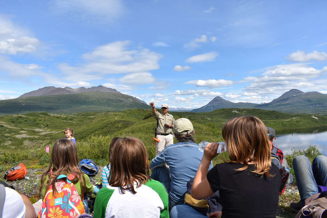 BLM Archaeologist John Jangala shares the pre-history of the Tangle Lakes Area with a group of WISE hikers Tommy Matia/WISE Photo
|

Who We AreWISEfriends are several writers connected with Wrangell Institute for Science and Environment, a nonprofit organization located in Alaska's Copper River Valley. Most of these articles originally appeared in our local newspaper, the Copper River Record. Archives
August 2021
Categories
All
|
 RSS Feed

|
WISE is a
501(c)3 nonprofit organization |
Contact Us |