
|
Copper River Record November 2016 By Robin Mayo Technically, the Tangle Lakes area is not really the Copper River Basin, but since so many of us love to hunt, fish, pick berries, and explore in this area, I couldn’t resist including a hike. The first few miles of the Denali Highway from Paxson are still in the Copper River Watershed, but the Lower Tangle Lakes drain into the Delta River and therefore this hike is actually in the Yukon River Watershed. A little further out the road, the McClaren River flows to the Susitna and on down to Cook Inlet. So you can experience the headwaters of three great Alaskan rivers in just a few miles. No wonder it feels like the top o’ the world up there! Many trails leave the Denali Highway in this area, and you can have your choice depending on your mode of transport. Hikers are forewarned though, many of the trails frequented by off-road vehicles feature a lot of mud! A favorite quick Tangle Lakes hike takes off from the BLM Campground, 21.5 miles from Paxson on the Denali Highway. Take the spur road from the highway towards the campground, then look for the trailhead on the left as you enter the campground. The well-developed trail traverses up the ridge, revealing awesome views of Tangle Lakes and River. At the top of the ridge the route gets somewhat less defined, branching out. This gives you the perfect chance to explore the network of open ridges. On a recent berry-picking foray we found not only fantastic blueberries and lingonberries, but also bearberries, crowberries, timber berries, and nagoon berries. On one of the larger open patches at the top of an old glacial moraine, someone has arranged loose stones into a spiral maze. Normally I’m not a fan of finding signs of human intervention in an otherwise pristine place, but this spot feels magical enough that it works. We were feeling fanciful late one evening and tried a slow walk to the center of the spiral, hoping it would transport us through time. We were miraculously transported to the future, about 2 minutes from when we began! The exercise did spark a great conversation about when in history we’d like to visit. My choice: ride the Copper River and Northwestern Railway in the 1920s. Taking care to keep your sense of direction, you can continue to explore almost indefinitely from this spot. Since you are in the Tangle Lakes Archaeological District, keep an eye out for signs of long-ago hunters, and please be respectful of anything you find. I guess the time travelling really does work, because this area always fills me with a feeling of peace and connection to those who came before us. 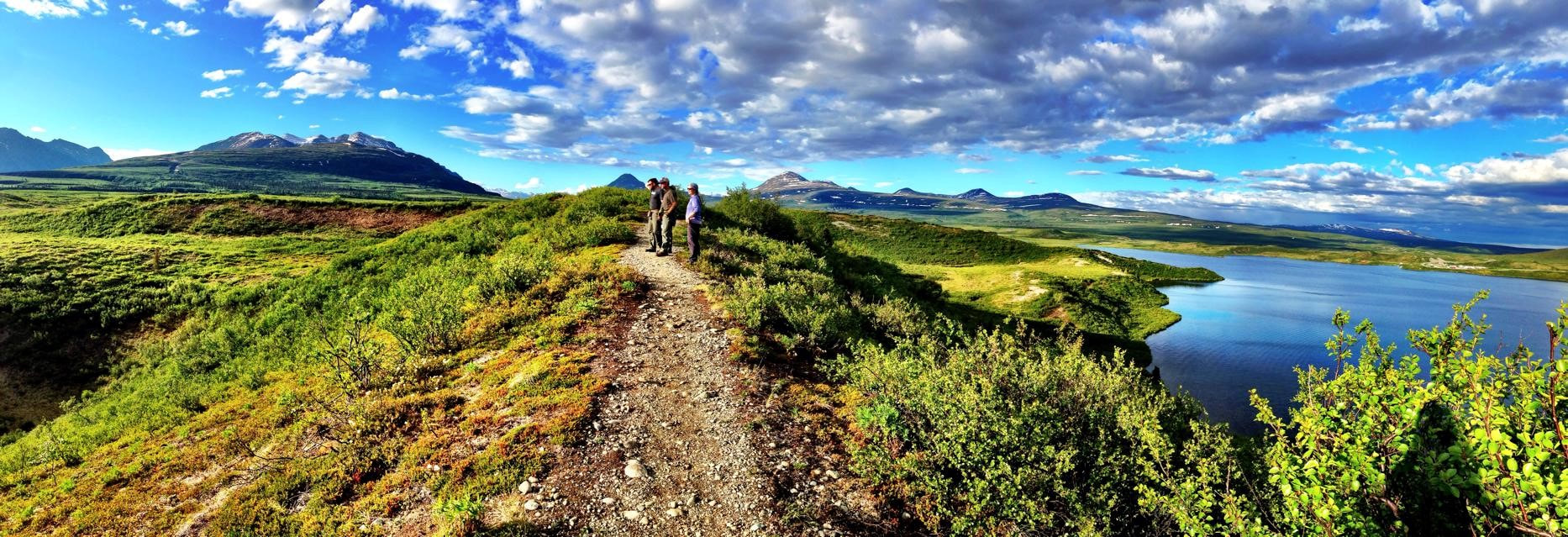 This trail never fails to reward you with panoramic views. Lauren Vos photo 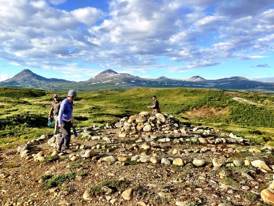 Exploring a spiral maze at the top of the Tangles Ridge Trail. Lauren Vos Photo
0 Comments
Copper River Record November 2016 By Robin Mayo For this week’s armchair hike, let’s head north to the Nabesna Road, and the Skookum Volcano Trail in Wrangell-St. Elias National Park and Preserve. I’m embarrassed to admit how many years I lived in this valley before I started venturing onto the Nabesna Road, so now I’m trying to make up for lost time. The trailhead is at mile 36.8 Nabesna Road, a solid hour drive East from Slana. Stop in or call the Slana Ranger Station to check on road and trail conditions, and learn about the fascinating geology of the area. The trail is 2.5 miles with a 2800 foot elevation gain, and includes scrambling through rocks and multiple crossings, so it is a serious outing. Since it is an up-and-back trail, you can choose how far you go. I’d plan on at least 4 hours to go to the top and back. The first mile or so winds through a spruce and alder forest, climbing steadily. Then you pop out of the forest and onto the streambed, with multiple shallow crossings. There is no developed trail once you are out of the forest, but cairns mark the best route. Once again I’ve led you on a hike with “Volcano” in the name, but there is no fiery lava! False Advertising! Does it help to know we are ascending up into the cone of a long-extinct volcano? Geology buffs will find much to explore. The cobbled streambed contain fascinating rocks from all three groups: igneous, metamorphic, and sedimentary. Cut banks along the streams show layers of volcanic activity, and the surrounding landscape tells a story of a violent eruption and subsequent erosion. Stream crossings while hiking are a challenge. If the water is low and you are agile, you may be able to hop from rock to rock, but most of us will get our feet wet. Also, acrobatic leaps on slippery rocks are a good way to get hurt, so don’t risk real injury. Taking off your shoes and crossing barefoot is not recommended, as the water is extremely cold and the rocks sharp and slippery. Waterproof boots are an option, or put some bread bags over your socks to make any footgear waterproof. Some choose to carry light sneakers or sandals to change into for the crossings. Regardless of your strategy, you may want to bring along a spare pair of dry socks! As a bonus, a large band of Dall’s sheep can often be seen in the area. Late one June evening I spent a fantastic hour with my binoculars, watching lambs cavorting and ewes grazing, a rare treat. Another party we met on the trail had surprised a grizzly, so we made lots of noise and kept our bear sprays handy, especially once we got into the thick brush near the trailhead. There are also ground squirrels and marmots near the alpine areas of the trail. Driving from the southern end of the Copper Valley and hiking this trail made for a very long day. Next time, I’ll spend the night at one of the campgrounds on the Nabesna Road and do some more exploring. 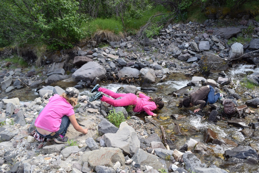 Few can resist sticking their face in the cold water of Skookum Creek on a hot day. As with all backcountry water in Alaska, it should be filtered, treated, or boiled before drinking. Jamie Dawson Photo
Copper River Record October 2016 By Robin Mayo One of the most fun and unique hikes in the Copper Valley can be found in a very unlikely place. Fourteen miles East of Glennallen on the Glenn Highway, down a gravel road to the idyllic Tolsona Wilderness Campground, and a mile on foot through a black spruce forest is a surreal landscape, the Tolsona Mud Volcanoes. If you are expecting a classic cone and dramatic fiery eruptions you’ll be disappointed, but if you are looking for an educational and adventurous outing with kids or visitors this is a sure winner. Mud Volcanoes are formed when gasses bubble up through layers of the earth, picking up water and mud as they rise. The Tolsona group consists of 3 cones, two of which are connected to the campground trail. The cones are large rounded hills, with vegetation on the lower slopes, and the active vents located at the top. The vents look like mud puddles, but are actually very deep, and bubble constantly with methane gases and fine, slimy clay. There are only a couple of hundred mud volcanoes in the entire world. The trailhead is located at Tolsona Wilderness Campground, and the proprietors ask visitors to check in and pay a very reasonable fee for parking. They can direct you to the beginning of the trail, which is marked with old CD’s tacked to the trees. It is about a mile meandering through the muskeg before you start to climb up the slight incline, noticing the changes in the vegetation as you get closer to the active cones. The trail is marshy in many places, but you’ll definitely be wearing rubber boots, so try to go straight through instead of making new trails around the wet spots. The vents offer plenty of fun, whether probing for the bottom, playing in the mud, or admiring the tracks of the many animals that frequent the place. Please be careful, especially with children, as the vents are deep, and the mud around the edges treacherously sticky. There are long poles nearby which could be used for rescue in an emergency. A favorite occupation is trying to capture the bubbling gases, then igniting them. We’ve tried it many times, and the most successful contraption has been a gallon ziplock bag taped to a forked stick. We left it there for about a half hour, then carefully sealed the bag, and pushed the gas out through a small hole. Having failed so many times, we were unprepared for success, and nearly lost our eyebrows when the concentrated gases burned with a dramatic whoosh. It’s nearly impossible to visit the mud volcanoes without getting at least a little muddy, and many explorers end up coated from head to foot. On WISE hikes, no one is allowed back into the van until they have rinsed off in Tolsona Creek, which runs conveniently right next to the parking area. You may want to bring plastic bags to cover your vehicle seats and protect them from the inevitable water and slime. If an outing can be measured by how tired and dirty we are at the end, any trip to the Tolsona Mud Volcanoes is a sure success. Tolsona Wilderness Campground can be reached at 822-3900 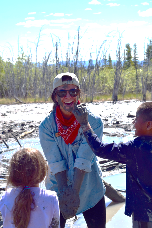 WISE summer intern Kiana Jenkins gets a facial at Tolsona Mud Volcano. Jamie Dawson Photo
Copper River Record October 2016 By Robin Mayo It always feels sad to drive past the boarded-up Copper Center School, remembering trade fares and many good times when the school was the center of the community. One way to keep the place alive is to keep using the sweet little trail behind the playing field. It is short on drama but full of charm, and an easy destination for young families, or those who want a gentle walk. The bugs can be fierce in early summer, so come prepared, or wait until August to sample this pretty hidden gem. Take the Old Richardson Highway, then turn east on Silver Springs Road, which is about a mile from the north end of the Old Rich. At the bottom of the hill is Copper Center School, where you can park in the lot. It is heartening to see that the playground and grounds are clean and in good condition, I suspect local families have worked hard to keep the site inviting. At the edge of the parking lot is a small sign with history and a sketch map of the trail, so you know when to take a turn off of Ancestors Ave and onto Windchime Way. Walk through the playground to the playing field beyond, then along the north end of the field to the log arch and trailhead at the Northeast corner. The trail consists of two easy joined loops, so you can choose the length that suits you. The forest is mostly Quaking Aspen, with some White Spruce and Balsam Poplar. As the Aspen mature some of them are falling down, and one can see signs of succession in action, where the spruce are pushing their way up through the Aspen and shading them out. Along the way are delightful birdhouses and windchimes built by the students, and an outdoor classroom with benches and firepit. You can explore it all in an hour, with time to frolic in the dandelion-filled field. We held Youth Environmental Summit there in 2014, and the youth made us laugh by dusting their skin with the abundant pollen. This nice level trail also makes a nice ski or snowshoe outing. I must confess that I have not walked it recently, so there may be trees down across the trail. This trail and school hold so many memories for the community, it is a delight to wander down the paths. 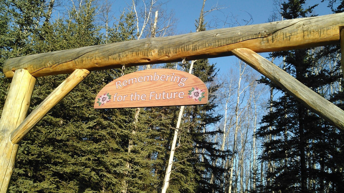 The motto above the log arch was perfectly chosen for this walk down memory lane. 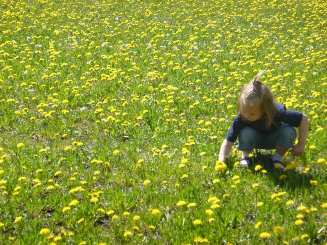 The dandelion strewn field at the beginning of the trail is a treat for all.
Copper River Record October 2016 By Robin Mayo Mile 24.8 Edgerton Highway. 2 miles round trip, 350 feet elevation gain. This winter, we invite you to learn about the many hiking opportunities in the Copper Basin. Armchair hikers can explore from one end of the valley to the other without leaving their cozy fireside seat! Each week we will feature a different hike in the hopes of inspiring many adventures when hiking weather returns. We’ll also delve into hiking etiquette, land management quandaries, and ramble on about gear, weather, and food. If you have a favorite hike you’d like to share, please contact me: 822-3575, robin@wise-edu.org. The Liberty Falls Trail is one of the most perfect short hikes in the valley, with a well-developed trail, incredible views, and even several opportunities to jump in the water and cool off. It is easy to miss, though, as the trailhead is not at the Liberty Falls Campground, but about 100 yards west at mile 24.8 of the Edgerton Highway. The trailhead has a BLM-maintained kiosk with map and sign-in. The hike is about 2 miles total, out and back, and includes some steep sections, especially at the beginning. It climbs up the ridge through a dense spruce forest before breaking out at the top of the ravine overlooking Liberty Creek. To the North there are awesome views of the Copper River and the Wrangell Mountains beyond. The contrast between the sheltered forest and lichen-covered rocky ridge make the climb worthwhile. Plant lovers can enjoy a wide variety of ecosystems in a short hike. Parasitic Broomrape, which looks like an elongated spruce cone, can be found under the Alders near the trailhead. On the ridge, tiny alpine flowers thrive in shallow scraps of soil among the rocks. The trail then continues along the ridge, with occasional short ups and downs. The official end is a gorgeous rock outcropping, the perfect setting for a picnic lunch. On a hot day, you may be tempted to continue another quarter mile down to the small lake for a refreshing dip. Like many of our local trails, this is an out-and-back trail, and we wish it was longer. I’ve heard rumors of using Liberty Falls Trail as a jumping off spot to get up into the high country to the south, but have never tried it myself. It looks like there would be considerable bushwhacking involved. A better bet for accessing the Chugach in that area is the Tiger Mine Trail/Road, which we’ll cover later. 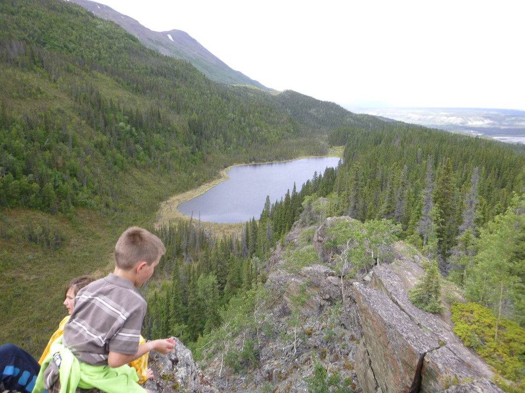 Just beyond the “official” end of the Liberty Falls trail, this little lake beckons on a hot day. WISE photo
By Janelle Eklund
On a mild June 4th day clouds hung in the sky moving with the wind and letting the sun peak through now and then. Twenty eight hikers of all ages gathered in a circle at the Liberty Falls trailhead listening to instructions on bear and trail safety and etiquette. The youngest of the group was two and half and he just happened to be the Executive Editor of the local newspaper. Or should I say, his soon-to-be-born brother was the youngest on this hike - except he had an easy ride and didn't have to climb like his brother - hah! Everyone was eager for the adventure up the trail. And UP it was! The first part of the trail was a steep climb through the boreal forest. As we came out of the trees rocky outcrops were bobbing with alpine flowers. The wind was howling up the Copper River and pounding us with its fury. We found a spot that was somewhat protected by the onslaught and settled down for a lesson on wilderness first aid splinting techniques. A lesson was led showing how to use tools at hand to improvise a splint for a broken arm. These tools consisted of anything from sticks to the clothes on your back. Another demonstration showed how to turn a t-shirt into a long bandage by starting at the bottom of the shirt and cutting in a circular pattern all the way to the top. Coats and shirts were used for padding and bandannas for securing. A few conventional tools were utilized like Sam splints and triangular bandages. As I filtered through taking pictures I heard comments like - 'this is fun!' Hunger pangs were taking hold and lunches started creeping out of packs. The wind was relentless and if you didn't want it to take your lunch it was best to hang on to it. Tummies satisfied, we continued the trek. The up and down steep rocky mounds didn't deter anyone from turning around - even the two and a half year old Executive Editor of the paper! No, he was in his element. At that age the term 'curtain climber' has significant meaning. But this little one is a 'mountain climber'. He gave us a lesson or two. If it's too steep going down you just sit on your bum and take it slow and easy. If it's too steep going up you just bend over and use all fours. Needless to say to do this he had to put the tape measure he was carrying in his pocket. Don’t ask me why he was carrying a tape measure. The end of our trek was a large rocky point overlooking a lake below with a backdrop of the Kenny Lake area in the distance. Lingering there awhile everyone enjoyed the view and rest contemplating the beauty of the land. The trek back was much the same. Curtains of transparent rain clouds drifted across the Copper River drainage, obscuring the Wrangell Mountains in the background. A few drops kissed our faces and immediately dissipated. I had the pleasure of following the Executive Editor down the trail. I was very impressed. He walked the whole way (1 1/2 to 2 miles) up and down steep terrain without a whimper and brushing aside any help! I was also impressed with mom and her soon-to-be-born son, making the trek with ease. Back at the trailhead, where the wind was calm and the mosquitoes were not, a lesson was given on wilderness hypothermia. The youngsters enjoyed learning to wrap someone snuggly in a sleeping bag surrounded by a tarp to keep them warm. It was a good day. The camaraderie was contagious, the views were spectacular, the lessons were fun and educational, the trek was invigorating, and the wind kept the mosquitoes down. What more could you ask for? From my light to yours- This hike was sponsored by Wrangell Institute for Science and Environment |

Who We AreWISEfriends are several writers connected with Wrangell Institute for Science and Environment, a nonprofit organization located in Alaska's Copper River Valley. Most of these articles originally appeared in our local newspaper, the Copper River Record. Archives
August 2021
Categories
All
|
 RSS Feed

|
WISE is a
501(c)3 nonprofit organization |
Contact Us |