
|
Copper River Record November 2016 By Robin Mayo Technically, the Tangle Lakes area is not really the Copper River Basin, but since so many of us love to hunt, fish, pick berries, and explore in this area, I couldn’t resist including a hike. The first few miles of the Denali Highway from Paxson are still in the Copper River Watershed, but the Lower Tangle Lakes drain into the Delta River and therefore this hike is actually in the Yukon River Watershed. A little further out the road, the McClaren River flows to the Susitna and on down to Cook Inlet. So you can experience the headwaters of three great Alaskan rivers in just a few miles. No wonder it feels like the top o’ the world up there! Many trails leave the Denali Highway in this area, and you can have your choice depending on your mode of transport. Hikers are forewarned though, many of the trails frequented by off-road vehicles feature a lot of mud! A favorite quick Tangle Lakes hike takes off from the BLM Campground, 21.5 miles from Paxson on the Denali Highway. Take the spur road from the highway towards the campground, then look for the trailhead on the left as you enter the campground. The well-developed trail traverses up the ridge, revealing awesome views of Tangle Lakes and River. At the top of the ridge the route gets somewhat less defined, branching out. This gives you the perfect chance to explore the network of open ridges. On a recent berry-picking foray we found not only fantastic blueberries and lingonberries, but also bearberries, crowberries, timber berries, and nagoon berries. On one of the larger open patches at the top of an old glacial moraine, someone has arranged loose stones into a spiral maze. Normally I’m not a fan of finding signs of human intervention in an otherwise pristine place, but this spot feels magical enough that it works. We were feeling fanciful late one evening and tried a slow walk to the center of the spiral, hoping it would transport us through time. We were miraculously transported to the future, about 2 minutes from when we began! The exercise did spark a great conversation about when in history we’d like to visit. My choice: ride the Copper River and Northwestern Railway in the 1920s. Taking care to keep your sense of direction, you can continue to explore almost indefinitely from this spot. Since you are in the Tangle Lakes Archaeological District, keep an eye out for signs of long-ago hunters, and please be respectful of anything you find. I guess the time travelling really does work, because this area always fills me with a feeling of peace and connection to those who came before us. 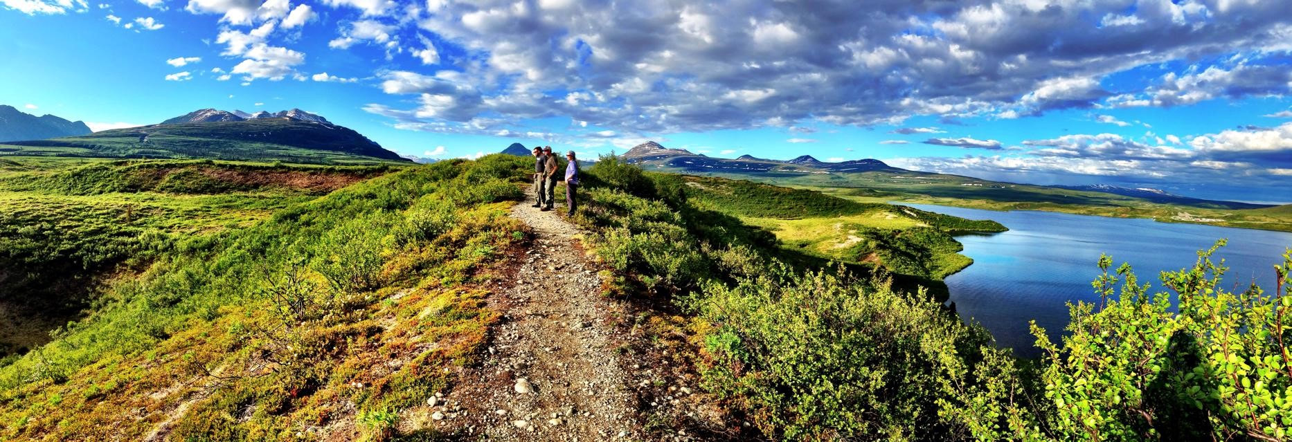 This trail never fails to reward you with panoramic views. Lauren Vos photo 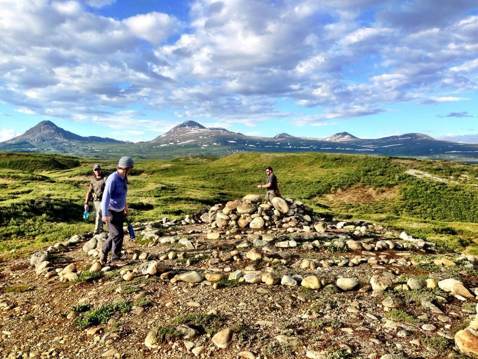 Exploring a spiral maze at the top of the Tangles Ridge Trail. Lauren Vos Photo
0 Comments
Copper River Record November 2016 By Robin Mayo For this week’s armchair hike, let’s head north to the Nabesna Road, and the Skookum Volcano Trail in Wrangell-St. Elias National Park and Preserve. I’m embarrassed to admit how many years I lived in this valley before I started venturing onto the Nabesna Road, so now I’m trying to make up for lost time. The trailhead is at mile 36.8 Nabesna Road, a solid hour drive East from Slana. Stop in or call the Slana Ranger Station to check on road and trail conditions, and learn about the fascinating geology of the area. The trail is 2.5 miles with a 2800 foot elevation gain, and includes scrambling through rocks and multiple crossings, so it is a serious outing. Since it is an up-and-back trail, you can choose how far you go. I’d plan on at least 4 hours to go to the top and back. The first mile or so winds through a spruce and alder forest, climbing steadily. Then you pop out of the forest and onto the streambed, with multiple shallow crossings. There is no developed trail once you are out of the forest, but cairns mark the best route. Once again I’ve led you on a hike with “Volcano” in the name, but there is no fiery lava! False Advertising! Does it help to know we are ascending up into the cone of a long-extinct volcano? Geology buffs will find much to explore. The cobbled streambed contain fascinating rocks from all three groups: igneous, metamorphic, and sedimentary. Cut banks along the streams show layers of volcanic activity, and the surrounding landscape tells a story of a violent eruption and subsequent erosion. Stream crossings while hiking are a challenge. If the water is low and you are agile, you may be able to hop from rock to rock, but most of us will get our feet wet. Also, acrobatic leaps on slippery rocks are a good way to get hurt, so don’t risk real injury. Taking off your shoes and crossing barefoot is not recommended, as the water is extremely cold and the rocks sharp and slippery. Waterproof boots are an option, or put some bread bags over your socks to make any footgear waterproof. Some choose to carry light sneakers or sandals to change into for the crossings. Regardless of your strategy, you may want to bring along a spare pair of dry socks! As a bonus, a large band of Dall’s sheep can often be seen in the area. Late one June evening I spent a fantastic hour with my binoculars, watching lambs cavorting and ewes grazing, a rare treat. Another party we met on the trail had surprised a grizzly, so we made lots of noise and kept our bear sprays handy, especially once we got into the thick brush near the trailhead. There are also ground squirrels and marmots near the alpine areas of the trail. Driving from the southern end of the Copper Valley and hiking this trail made for a very long day. Next time, I’ll spend the night at one of the campgrounds on the Nabesna Road and do some more exploring. 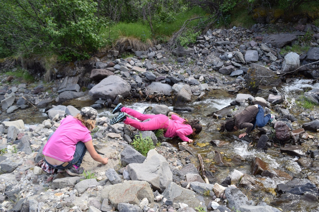 Few can resist sticking their face in the cold water of Skookum Creek on a hot day. As with all backcountry water in Alaska, it should be filtered, treated, or boiled before drinking. Jamie Dawson Photo
|

Who We AreWISEfriends are several writers connected with Wrangell Institute for Science and Environment, a nonprofit organization located in Alaska's Copper River Valley. Most of these articles originally appeared in our local newspaper, the Copper River Record. Archives
August 2021
Categories
All
|
 RSS Feed

|
WISE is a
501(c)3 nonprofit organization |
Contact Us |