
|
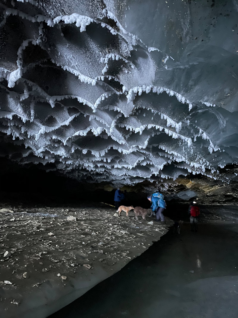
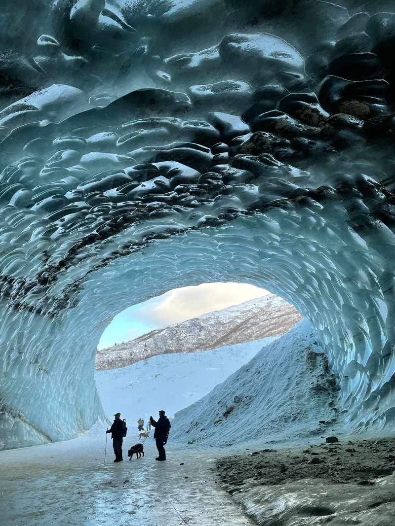
By Robin Mayo If you are looking for an adventure that is within reach and family friendly, I highly recommend planning a trip to the Castner Glacier Ice Cave. With a two-hour drive from Glennallen and a one-mile walk, you can access a truly breathtaking experience. The cave is approximately 50 feet wide and 40 feet tall at the entrance, and tapers as it goes back about 200 feet into the glacier. (Note: these numbers are pure estimate, I’m wishing I’d done some pacing!) Part of the floor is smooth ice, and the rest a mix of ice, dirt and rocks. We followed the curving cave until it was pitch dark, and the ceiling was too low for walking. Best of all, it seems to be pretty stable in the winter, so it can be explored in relative safety if basic precautions are followed. One of the surprises for me was how many other people were there! On a December weekend we saw about 40 other people on the trails and at the cave, and I’d estimate there were over 100 on a weekday during the holiday break. It was fun to see so many people respectfully sharing the trails and enjoying themselves, but if you want to experience the place in solitude you may need to choose a weekday and/or be prepared to wait patiently. Near the entrance, the ice was shining, with a unique scalloped texture and run through with ribbons of gravel reminiscent of polished marble. Further in, the ceiling is festooned with ice crystals, some reminding us of perching butterflies, and others needle-sharp or feathery. We could hear water gurgling beneath the ice, and a few damp spots reminded us to be very cautious. The cave is accessed from the Castner Creek Bridge at mile 217.3 Richardson Highway, about 20 miles north of Summit Lake. Two trails go to the east up the creek, one from the parking area at the southeast corner, and the other about 100 feet north of the bridge. DOT has made crude but usable parking areas around the bridge. At my last visit in early January both trails were beautifully hard packed and easily walked. About halfway to the cave they come together on the creek. The trails are mostly similar and both well used, but the southern one included a steep 15 foot drop down to the creek, and the northern one is partly in the woods so more sheltered. If you go, I’d recommend checking the weather for Delta Junction and Paxson to get some idea of conditions. This is a notoriously windy area, so come prepared with extra layers for the wind chill. I’d also recommend having snowshoes or skiis available in case the trail is blown in, which was the case on my first visit in December. Although this is a relatively easy adventure, please have safety in mind. There was no cell phone coverage, so someone should know where you are and when you plan to return. Much of the trail is on an active creek, so give open leads a wide berth and be alert for new holes, which could open up even in the trail. At the cave, you may want walking sticks and/or cleats for your boots to make it safer to walk on the ice. There are rocks suspended in the ice which could fall, especially as the weather gets warmer. And towards the back of the cave, we could hear water and saw evidence of recently overflow and seepage, so be very cautious on the ice. If you want to explore the very back of the cave you will need a flashlight or headlamp, which we also found very useful for getting good photographs. Families with young children might want to bring along a sled for taxi service for tired little explorers. Although this place feels like the middle of nowhere, it is important to be prepared for and considerate of other visitors. The parking areas are small, but workable if people don’t hog space, and are careful not to block other vehicles. Lots of dogs were enjoying the adventure, but everyone had leashes and was keeping their pet close, which I appreciated. The walk is so short a snowmachine would be needed only for someone who couldn’t make it otherwise. If you do bring your machine please yield to foot traffic, who have the right of way. In a place like this, it is also courteous to stay on the trail as much as possible, to keep the views pristine and also avoid creating lots of side trails which make the main trail hard to follow. I wish I knew more about the history and geology of this cave, which appears to be formed from the combination of the stream running underneath, and the warm summer air melting out the entrance. It sounds like it has been there for quite a few years. The mouth of the cave faces roughly northward, which means it is spared long exposure to the sun which would speed up the melting. WISE is considering leading some hikes there later in the winter, if you are interested please let me know and I’ll fill you in on details, or keep an eye on the WISE FB page and website.
0 Comments
Copper River Record October 2017
By Robin Mayo Before hanging up our boots and backpacks for winter, we took one final hike last week. As WISE plans for the next season, we are always looking for new places to explore. We are also planning a major new program for next summer, Outdoor Wilderness Leadership Skills (OWLS) which will begin with a multi-day backpacking trip. With this is mind, we headed to the Nabesna Road to check out the Caribou Creek Public Use Cabin. As we drove north, the light skiff of snow from the night before thickened to a good blanket, and we found about four inches of fresh snow on the Nabesna Road. We even stopped to get out and turn those old-fashioned manual hubs on the Truckling in case four-wheel drive was needed. At this time of year choice of footgear is always a dilemma. I opted for my Extra-Tuffs, while Mikaela chose waterproof hiking boots and gaiters. Both choices worked well, although I compromised on traction, and she had to pick her way carefully at the stream crossings. Parking for the trail is at Mile 18.5 Nabesna Road, and the trailhead is about a quarter mile further east. I was a little apprehensive about the approximately one thousand foot elevation gain shown on the map, but the first half of the trail was a gently but steady uphill on a very solid and wide trail, winding through the spruce forest. It is three miles to the cabin, a nice distance for slightly out-of-shape backpackers like yours truly. At about the halfway point, the trail crosses Caribou Creek at a wide ford with a nice solid gravel bottom. I imagine that during spring runoff it could be deep enough to be worrisome, but we made our way across easily without getting wet feet. From there the trail got steeper and somewhat rougher as it climbed up into the v-shaped valley. With the snow covering the trail, we did a little slipping on roots and rocks, but the double-track trail was always easy to follow. Right at timberline, and right when my legs were starting to drag and the shallow layer of snow feel like postholing, we arrived at the cabin. It is a welcoming sight perched on a relatively level spot above the creek. The last user had left the cabin nicely stocked with dry spruce branches for kindling, and a couple of nice logs to get our fire started. We were also glad to find plenty of dry willow available nearby, and a good sized spruce log to cut up. The cabin has an axe and saw, but we were glad for the sharp saw we brought. My favorite camping saw is a small, inexpensive sharp-toothed carpenters saw, which performs much better than a bow saw. The Caribou Creek Cabin is about 10 by 12, with two bunks, windows, a counter, and most importantly a good wood stove. The heavy stove with fire brick was slow to warm up, but very satisfactory once it got going. Bear shutters cover the windows, and we were careful to replace them when we were ready to leave. Wrangell-St. Elias National Park seems to make a tradition of situating outhouses with superlative views, and this privy did not disappoint. We hiked through layers of clouds on our way up, but in the morning were treated to views across the valley to the South, including the “backside” of Mt. Wrangell. Hiking to a cabin makes camping so much more comfortable in the fall, it would have been a damp and chilly experience in a tent. We also enjoyed very light loads, just bringing pads, sleeping bags, a few extra layers, pots, and food. For me one of the highlights of visiting a public use cabin is reading the logbook. Although the Caribou Creek book lacked the character development and highly developed plot of the Nugget Creek Logbook (See March 23 Copper River Record for highlights) it did have some gems, including a proposal made with a candy ring, bear encounters, and puzzle angst. Easy boys, it’s just a picture printed on bits of cardboard! We hiked back out on a sunny day, squinting in the bright reflected sunlight, and felt ready to let go of fall and embrace winter. Copper River Record October 2017 By Robin Mayo Armchair hikers, are you ready for another season? Until the snow flies the hiking is still great, but after a busy summer I’m ready to relax a little, explore some maps and dream about next summer. For sheer challenge and drama, you just can’t beat a hike up Willow Mountain. The trail is steep but easy to find and follow, and the views from the top are unsurpassed. With the base at about 1500 feet elevation and the summit at 3300 feet, the approximately 2 ½ mile trail is wide, smooth, and solid. Folks in great shape can get to the top in 2 hours or less, and descend in about an hour, but for the rest of us plan on a full day of hiking, with lots of breaks to catch your breath and enjoy the breathtaking vistas. Willow Mountain is located near Mile 88 Richardson Highway, the pullout at Willow Lake is a good place to park and access the trail. The land is owned by Ahtna, Inc. who welcomes people using the resource with the purchase of a land use permit. One day or season-long use permits can be obtained by contacting the office in Glennallen at 822-3476. Hikers should carry extra water, food, and warm, windproof layers. Even on a hot day, the summit can be quite chilly and windy, and you will want to linger. Sturdy footwear is recommended, as the trail is steep enough to have the gravel rolling under your feet, and turn your legs to jelly. I’ve heard some locals refer to Willow Mountain as “Bear Mountain,” and we often see bear sign, so plenty of noise and protection are recommended. From the north end of the Willow Lake Pullout, cross the Richardson Highway and get on the Alyeska Pipeline Right-of-Way. Alyeska allows use of the ROW for short stretches, but asks that large groups give them a heads up so they know what is going on. Turn left to head south on the pipeline, and follow the right-of-way for about a mile. Shortly after a yellow and black sign that says 7-11, start looking to the right for a 4-wheeler trail heading up into the woods. It will go around a gate and onto the powerline, follow the powerline for a while, then head up the mountain. There are no other major trails in the area, so it should be easy to find your way. This first section of the trail goes through an unusual forest for the Copper Basin. The dominant trees are large paper birch, which only grow in a few small patches elsewhere in the Southern Valley. I’ve often wondered what conditions led to this isolated but very robust birch grove. After several very steep stretches going up the eastern face of the mountain, the trail curves around the shoulder, and completes the climb up the southern side of the mountain. Steep sections alternate with not-quite-so-steep stretches, and great vistas abound. Right before the summit there is a level saddle with a nice alpine meadow, then the trail leads up to the communications towers at the summit. The hum of the equipment is a bit of a distraction, but the convenience of the well-built and maintained double track trail is worth putting up with a little civilization. As well as the Wrangell Mountains and surrounding lakes and rivers, great views of the Alaska Range, Chugach, and beyond can be seen from the summit. On the long gentle slope north of Mount Drum, look for the distinctive bumps of the Klawasi Mud Volcanoes. This is also a great place to ponder the fact that a huge lake called Lake Ahtna used to fill the Copper River Valley. Glaciers blocked the gap where Woods Canyon now lets the Copper River flow through the Chugach Mountains, and the top of Willow Mountain was an island! Once I thought I got a glimpse of Russia, but was quickly corrected, as I was looking east. So I reckon it must have been Greenland. 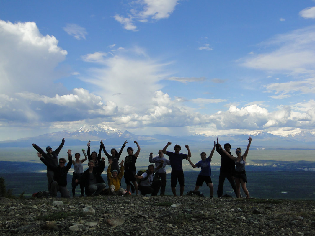 Copper River Stewardship Program students and staff celebrate a climb up Willow Mountain in 2015. CRSP Photo
Copper River Record July 2017 By Robin Mayo Last week, WISE hikers were treated to a new perspective on an old favorite location. BLM Archaeologist John Jangala led a hike in the Tangle Lakes Archaeological District, and showed us how to discover ancient evidence of hunters and gatherers in the area. The Tangle Lake Ridge Trail takes off from the BLM campground at mile 21 Denali Highway, and makes a long diagonal traverse up the ridge. This area was heavily glaciated, and the series of rolling hills are actually old eskers, the streambeds under the glacier which create ridges of gravel. The Ahtna people have used this area for over 10,000 years as a prime spot for fall hunting and berry picking. At the top of the ridge, we emerged from the brush and took a lunch break on the bare domes of gravel that top the ridge. John showed us how to observe carefully, looking for stones that were shaped like chips or flakes instead of the glacial-rounded ones that were the norm. He brought along an example of a larger stone that small tools were flaked from. Soon we were finding small remnants that told the story of ancient hunters sitting on this same spot. Stone age tools in the area were made of a rock called Landmark Gap Argillite, and there are several sources of it in the Amphitheater Mountains. Compared to obsidian and other stones commonly used for tools, it is very humble in appearance, a sandy grey-brown color. The small pieces we found were often covered with lichens like the other stones, so it took a sharp eye to pick out their distinctive shape and color. When first flaked off, stone tools have such a sharp edge that they have been used for open-heart surgery. After some use the edge becomes duller, but can be re-sharpened by taking off tiny flakes to create a serrated edge which is useful in cutting tough tendons when butchering game. Dull blades could also find use as hide scrapers. Ancient hunters also made multi-pointed projectiles by embedding several tiny sharp stone shards in antler or bone holders, which were then lashed to wooden shafts. With a limited range, the hunters relied on their knowledge of the habits of the animals, and patiently waited near trails until the game came close enough to reach with a spear. They also used a one-handed holder to fling the darts or spears, to add to their speed. This technology was also shared with coastal hunters, who needed to be able to keep a boat steady while also throwing their weapon. As we ate our sandwiches, fruit, cheese, cookies, and other modern treats, we were struck by the difficulty of providing enough calories to live on year-round by hunting and gathering, even in the relatively rich Tangle Lakes area. We are so used to using large amounts of energy to acquire our food, including farming, processing, and shipping it from faraway places. Modern day subsistence hunting nearly always relies on petroleum powered transportation, and plenty of calorie-dense snacks to give the hunters energy. But to stay alive in the wild you’d need to keep ahead of the game, consistently procuring more calories than you consumed. Exploring and finding artifacts is exciting, but John stressed the importance of leaving things where they are found. Near high-traffic areas like the campground and local trails, they are most likely already known to the archaeologists, and leaving artifacts in place gives others the chance to discover and learn. If an interesting item is found off the beaten track, it should also be left where it is found. A good picture and GPS or Map coordinates are greatly appreciated by the Archaeology teams, so your find can become part of their knowledge base. 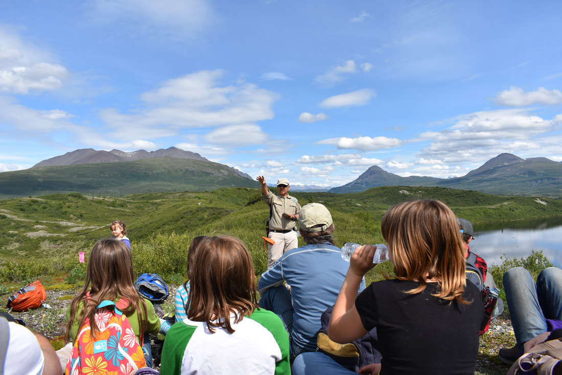 BLM Archaeologist John Jangala shares the pre-history of the Tangle Lakes Area with a group of WISE hikers Tommy Matia/WISE Photo
Copper River Record March 2017 By Robin Mayo “If these old walls, if these old walls could speak. What a tale they’d have to tell, hard headed people raisin' hell. A couple in love livin' week to week. Rooms full of laughter, if these old walls could speak.” Jimmy Webb Every old building feels like it is bursting with stories, especially cabins in the wilderness. I’ve always loved reading the tattered notebooks left in cabins to record visitors’ thoughts and adventures. The logbook at Nugget Creek Cabin in Wrangell-St. Elias National Park did not disappoint on a recent visit. The cabin is over 50 years old, with a long history as homestead dwelling, trappers refuge, and now public use cabin. And it is actually the new kid on the block, nearby are the tumbled remains of a mining settlement which is over 100 years old. Although the current logbook has been in use for only 5 years, it includes a rich and highly entertaining narrative. One especially chatty and opinionated writer has a long history in the area, and his annual entries are a great touchstone interwoven with the stories of diverse strangers from all over the world: “Thanks to the park service maintenance crew, the trail was easy to negotiate. Probably the best it’s been in my 45 years of annual visits. 1969 was the first year for the Copper River bridge, so traffic on the Nugget Creek trail really increased because of that access.” As you’d expect, stories of adventures on the trail are a common theme. “The first 17.5 miles were great, the last 500 ft. not so much….the creek completely changed course since I was here a month ago.” “About midway up the trail we nearly turned around. The mosquitoes were greatly diminishing our enjoyment.” “We got to the cabin at around 2:18 pm after leaving the car at 9am. The hike was easy, maybe a bit too flat.” “New snow formed great clumps on skis no matter what wax (even w/o wax) so we trudged with skiis on…quite a workout” Once travelers arrive at the cabin, the woodstove is a common topic: “I read past cabin notes where the folks rave about the heat output of the stove, but that is never my luck unless I put up with smoke in the cabin during the initial warm up” “We think the stove works great & wish the one in our own home was as nice.” Reading through many entries to get to the bottom of the stove controversy, I discovered that many of those who complained about excessive heat output were summer visitors who built and stoked a fire, then discovered the windows don’t open and the mosquitoes are abundant. One group who found the Plexiglas windows damaged by a bear ended up pitching their tent inside the cabin. Park rangers and maintenance staff usually leave short, businesslike notes, but one trail crew waxed poetic after finishing their unglamorous task: “Dug new outhouse hole and moved outhouse. Hopefully all who partake will find respite; if not, may they at least find relief. As always we strive to leave things better than before. The view from the previous throne was difficult to improve on, but we hope you find we did just that.” Their hard work did not go unnoticed: “The outhouse is kind of amazing, I’ve never done my business with such a view.” Wildlife also provides lots of stories: “Three NPS trail crew people were charged by a decent-size bull moose right outside the cabin while having a fire. So heads up! Bear and moose abound.” “The only wildlife we saw was a porcupine, & whatever Joanna ‘thinks she saw’ during a midnight nature’s call.” One of the most entertaining threads starts with this statement, on June 5, 2013: “We named the porcupine Harald.” When his name is later misspelled “Harold,” it is quickly corrected with reference to the page number and date of christening. “Harald the porcupine munched on the cabin all night. We tried to scare him off, albeit unsuccessfully. We are trying to figure out what nutrients he would get out of eating the cabin.” “Harald was around to see me last night—twice. His first feeding was at 0100, so I went out and took a picture of him. His dessert was at 0400….” “I have had luck in eliminating the ‘Harald’ issues! When he starts knowing (sic) on the logs (for salt I’m sure) I make sure other folks in the cabin are awake before I start beating the large and small steel dustpans against the stove walls. That maneuver has been 100% successful twice now….” “ P.S. Met Harald—what an a#@%&. Signed, Clean B & Dirty D” Then finally: “Harald the porcupine has decided to take an extended vacation, floating Nugget Creek with an intended stop in Chitina for some dipnetting.” The demise of Harald caused dismay to some tenderhearted visitors, but soon afterwards another porky named Ralph takes up where Harald left off, so visitors are not deprived of the experience of being kept awake by gnawing in the night. Human visitors to the cabin bring their own special moments and shenanigans: “He proposed at the top of a hill overlooking the glacier on a beautiful sunny day! Needless to say, Nugget Creek cabin and the view of the Kuskalana Glacier will always have a sweet spot in our hearts.” “I’m back with my daughter and grandson….” “This is his grandson. I am very ill-prepared by his standards. Yes, I did miss a few things...My Grandpa has the cutest little tools and methods to help him on these trips. My Mom and I laugh all the time.” “This is the daughter/mother of the previous two. I love those two guys! Getting out here is not so great for my hair, but so incredibly awesome for bonding with my two favorite men.” “Two Russians, one American. Wild mushrooms, wine & Kentucky straight bourbon whiskey. Rain...Abandoned Jeep, exhausted mine, dilapidated cabins. Rain. We ate, we read, we played, we smoked, we drank, and finally we tattooed ourselves.” “You always wonder what was on the pages that were torn out. By whom and why?” “A good place to turn 30 during a weird year.” “The kids loved it so much that they begged to stay out here. After a very brief discussion we agreed that it would not be inappropriate, and told them we’d be back before school starts to get them. They seemed to think that the bag of marshmallows and 4 snickers bars would be sufficient for 5 weeks. So if anyone happens to stop by, just be kind to the feral children and feel free to leave any food for them, and maybe a toothbrush.” This is just a sampling of the gems from the most recent 5 years at Nugget Creek Cabin, someday I’d love to peruse the older books as well. We didn’t meet a porcupine by any name, or encounter feral children, but enjoyed the warmth of the stove and added more echoes of laughter to this well-used and loved retreat in the wilderness. Before securing the bear shutters back on the door and windows, it felt like an honor to add our chapter to the never-ending story in the logbook. 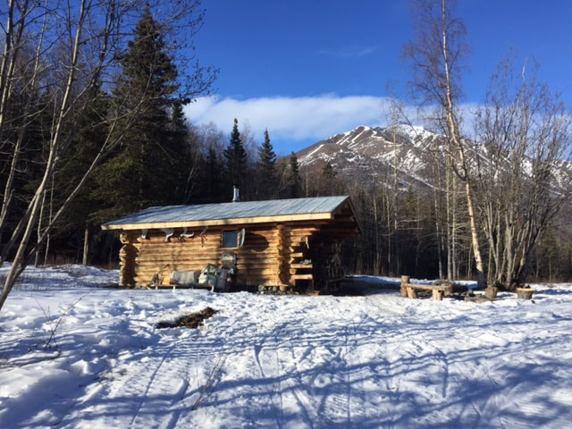 Photo: Nugget Creek Cabin, Photo by Kelly Smith Copper River Record February 2017 By Robin Mayo With the returning sun, there is more motivation to get outdoors on skiis or snowshoes, and explore some of our trails in winter. In fact, winter is the preferred time to travel across wetlands easily without risking damage to the fragile and essential ecosystems. The Tonsina River Trail heads south from mile 12.3 of the Edgerton Highway, and goes about 1.3 miles in a gentle downhill, first to the bluff, then west along the bluff to a gorgeous picnic spot overlooking the river. WISE often uses this location as an outdoor classroom where we can learn surrounded by panoramic views, birdsong, and the spicy scent of sage. There is a nice pullout on the south side of the road where you can park, and a small kiosk at the trailhead. The first half of the trail tends to be wet in the early part of the summer, and of course with our boots we dig the trench deeper and wider, compounding the problem. I like to wait to use this trail until a good dry spell, or towards the end of summer. Or why not explore it in winter and avoid the mud altogether? Locals ski this trail fairly often, so there is a packed base to support cross-country skiis or snowshoes. Like so many of our Copper Basin trails, the land status is a little complicated. The trail itself is on a 17(b) easement. Test time: who remembers this unique Alaskan land designation from my article several weeks ago on land status? Gold stars all around! In a nutshell, 17(b) Easements are special corridors which were created to allow access across lands that were conveyed to Native Corporations by the Alaska Native Claims Settlement Act (ANCSA.) When I was researching land status for this trail on BLM-Alaska’s Spatial Data Management System, I noticed that the Ahtna region is the only area of the state for which the easement data is complete. Way to go land managers! The easement for the Tonsina River Trail is only 25 feet wide, so please stay on the trail to avoid trespassing on surrounding lands. This trail is a great one for wildflowers, and we often come across wood frogs. Kids always want to hold critters they find, but may be unaware that frogs have a fragile and very important slimy skin covering that can be badly damaged by handling. It is best to observe them as they hop about, then let them go on their way unharmed. I always try to imagine how I’d feel if a giant frog picked ME up… Happy hiking everyone, and be sure to get out and enjoy the “warm” weather! 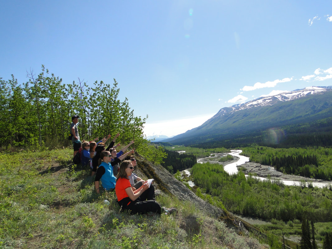 Copper River Stewardship Program 2013 students enjoy the view at the end of the Tonsina River Trail. Kate Morse Copper River Watershed Project Photo.
Copper River Record January 2017 By Robin Mayo Disclaimer: This is intended to be an introduction and summary, not the final word on a very complex issue! Since I started sharing the armchair hiking series, it seems there has been no shortage of topics for conversation at holiday gatherings, grocery checkout lines, and other hot spots for socialization. It has been great fun hearing about favorite hikes and gathering ideas for future columns. Inevitably, the conversation leads to some variation of one big question: How do I know where it is OK to hike? There isn’t one easy answer to this question, but a basic understanding of land ownership in the region helps. Obviously, hiking an established trail with a sign and kiosk at the trailhead guarantees that you have permission to go there. Even then, be aware—many trails are on fairly narrow easements crossing private land. But what about all the other cool places we are tempted to explore? Here is a simple summary of land ownership in the Copper Basin. We have vast amounts of public lands, owned by the state of Alaska or the federal government. State Lands are administered by Alaska Department of Natural Resources. Federal Lands in this area are looked after by either the Bureau of Land Management, or the National Park Service. With some exceptions, public lands are open for human powered recreation. Sometimes there is limited access or permits required, such as backcountry permits for National Parks. Wrangell-St. Elias has very few restrictions, permits are only required if you are with a large group, operating an off-road vehicle, or hunting. Staff at the BLM Glennallen Field Office are glad to answer questions or help you determine land status. Native Lands are private land owned by a regional corporation, a village, or an individual. In the Copper Basin, Ahtna Inc. owns a lot of land, Chitina Village and Chugach also have holdings in the southern regions. Native owned lands have no-trespassing policies, but some land managers provide ways you can get permission for recreational use. Ahtna, Inc. has a variety of passes available for purchase, from an individual day use for $15, to a $125 season pass. Chitina Native Corporation also has a permitting system for access to their lands. Following me so far? Here’s another layer of intrigue. 17(b) Easements are special corridors which were created to allow access across lands that were conveyed to Native Corporations by the Alaska Native Claims Settlement Act (ANCSA.) There are many of these routes scattered across the Copper Valley, and they can be used by anyone. You need to understand that the easements only allow you to cross, not to stop and camp, wander, pick berries, or hunt. Sometimes they are marked, or they can be found in the online tools detailed below. Private Land is scattered throughout the area, and of course should not be crossed without permission. There are also bits and pieces of land owned by the military, mental health land trust, and other entities, but in my experience they are not usually an issue. The Trans-Alaska Pipeline occupies a right-of-way, which is an easement across land owned by another entity. Alyeska does not mind hikers crossing the right of way , or travelling along for a short way to access recreational sites. But you still need to have permission from the land owner. If in doubt, you can contact the Glennallen Response Base to help figure it out. For large groups, long distances, or motorized travel they will usually give permission with a few days notice. Right of Way Use Guidelines (RUGs!) are available at Pump Stations and the Glennallen Response Base to help you understand the rules. Such entertaining reading—“A RUG is necessary for linear use of the ROW…” There are several online mapping tools available to help you research land status, and make sure your hike doesn’t become a trespass. These are very comprehensive databases that are made available to the public, but they aren’t what I would call user friendly for the average Jill or Joe. Depending on how you are with technology, it can be a ton of fun, or a hair-tearing frustration that has you swearing you’d rather live in a cave. Try enlisting the help of someone under the age of 30 with good intuitive techno skills, and make sure your computer and internet connection are smokin’. Alaska Department of Natural Resources Mapper (dnr.alaska.gov/Mapper) is a very thorough statewide database, but also pretty technical. Give yourself some time to figure it out and you will be rewarded with a wealth of information. The US Bureau of Land Management’s Spatial Data Management System (sdms.ak.blm.gov) is another very comprehensive, therefore potentially mind boggling database. At the time of this writing it does not seem to be active, perhaps because BLM is in the midst of a website update. I find it easier to navigate than Mapper, but that may be because I’ve worked past the frustration stage. Ahtna Inc. has a useful and easy to understand interactive map of Ahtna lands on their website (ahtna-inc.com/lands) and are happy to help anyone who comes in to identify Ahtna lands. And the Chitina Native Corporation has simple maps available (www.chitinanative.com)to help you figure out how to dipnet without trespassing. These tools will show you the general land status, but they do not list individual owners of private land, to determine this, you need to go to the State Recorders office in Anchorage, Palmer, or Fairbanks, or do an online search at (http://dnr.alaska.gov/ssd/recoff/default.cfm) Google Maps and ACME Mapper are two online mapping resources which don’t show land status, but can be a huge help in your research. BLM and the National Park Service both have paper maps available that can help with land status, but beware of old maps, because things change quickly. Confused yet? There is no easy solution, but I encourage you to learn about and be aware of land ownership issues whenever you are out adventuring. Yes, it can be a hassle, but in the long run respecting the land and the landowners is the best way for all of us to continue to access the places we love to explore. 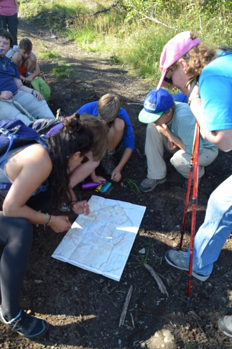 WISE staff, interns, youth, and adult hikers pore over a map
Jamie Dawson Photo Copper River Record January 2017 By Robin Mayo The Root Glacier Trail must be one of the busiest places in Wrangell-St. Elias National Park. On weekends it can almost reach traffic-jam status, with large groups maneuvering past each other on the narrow switchbacks nearly bring all traffic to a standstill. But other days you’ll have the place all to yourself. Either way, it is a guaranteed adventure suitable for almost every hiker. The trail begins in Kennecott, where you can stand among the grand old relics of the industrial past, and try to imagine a day when this valley swarmed with workers and buzzed with machinery. I love the contrast between the manmade and natural sights, and the way the forces of nature are having their way. Of course, just getting to the trailhead can be an adventure in itself. Give yourself at least 3 hours to drive the McCarthy Road from Chitina, then more time to walk across the footbridge and catch a shuttle van up to Kennecott. Be sure to stop in at the Ranger Station in the old general store for trail maps, updates, and safety information. Even on hot days, it is important to carry extra layers on this hike. Once you get close to the glacier, the air turns a lot cooler, and the slightest breeze can create a refrigerator effect with damp clothing. Sturdy boots are helpful for the steep hard trails, and essential if you will be putting on crampons and going on the ice. It is a 4-mile round trip, and can easily fill a day, so bring plenty of water and snacks. The wide, well maintained trail heads north up the valley, and several branches strike off to the mines and mountains beyond. The main trail is cut into the hill beside the Root Glacier, occasionally traversing a stream or diving into the surprisingly thick forest. It is about two miles up to a primitive campsite and access to the glacier. The trail continues on up the valley, but for now we’ll just go to the glacier. Head left down a steep zigzagging trail. There are tent spaces, bear boxes which are a bit tricky to find, and outhouses located up near the main trail. We spent a night last summer here with a large group of youth and adults, and there was much hilarity as convoys would form to make the trek to the latrine. Bears are abundant in the area, so be sure to take precautions to ensure a safe camp and unspoiled wildlife. Another quarter mile of switchbacks lead down to a good place to access the glacier. Crampons are necessary to walk safely, and I strongly encourage you to hire a guide or recruit an experienced friend if you want to go out on the ice. Several guiding companies in McCarthy and Kennecott offer reasonably priced options for guided glacier treks. There are many hazards, and rescue is difficult if you do end up in trouble in this remote location. For a day hike, exploring the moraines and admiring the expansive views in all directions make this destination a very worthwhile jaunt. I always enjoy meeting the groups hiking by, and watching tiny figures exploring out on the glacier. If you want to spend time out on the glacier, consider bringing camping gear and staying a night or two. In the early morning quiet, hearing the creaks and groans of the nearby ice are an unforgettable experience. There is nothing like a glacier to put things in perspective.  A primitive campsite on the lateral moraine is a welcome place to rest after a long day exploring the Root Glacier.
Copper River Record December 2016 By Robin Mayo Right behind Kenny Lake School is another hidden gem, a beautiful little trail complete with interpretive signs with student poetry, stories, and artwork. There is no signage on the highway, but everyone is welcome to explore this trail which winds through textbook Boreal Forest then connects with the trail along the brink of the Tonsina River bluff. Kenny Lake School is located at Mile 5 of the New Edgerton Highway. Park in the school parking lot, then follow the fire lane around the playground to the large field behind the school. At the SouthWest corner of the field, there is a small kiosk with trail information and a sign-in sheet. The trail is rustic, with some gentle ups and downs, and rough patches. Although it is less than a half mile to the bluff, you will want to give yourself plenty of time to enjoy the signs. It is especially fun if you know any of the kids who worked on the project as elementary students, and are now doing impressive grown up things like graduating from college and holding down real jobs. Where the school trail meets the bluff trail, there are comfy benches where you can sit and enjoy the sage-scented air and great views. Take a good look at the dirt of the trail for fresh tracks, bear and moose sign are common. If you head West on the bluff trail you will come to an outdoor classroom on a scenic point. Continue west and veer right to circle around back to school via the gravel pit, or veer left for a nice gradual descent down to the river. My favorite destination in this area is about a half mile East on the bluff trail, where there is another interpretive sign and a great place to view a dramatically eroded cutbank with interesting layers of volcanic deposit from long-ago eruptions. Please take care, the banks are constantly changing, and in many places are undercut. What looks like solid ground may be a matt of roots and topsoil hanging in the air. When we take youth groups to this area, the rule of thumb is don’t go near the edge unless you can see the solid slope below it. You can also connect to the trails on Wellwood Nature Preserve, which we will explore in a future armchair hike. In any season, this network of trails provides lots of options for hiking, skiing, or snowshoeing. The Tonsina River Bluff always has surprises in store, including the first Pasque flowers of the season, abundant wild roses, and even juniper berries. In summer there is almost always a breeze to chase away the mosquitoes, and on a wild wintry day it can be very exhilarating.  A group of WISE hikers at the lahar overlook with the Tonsina River in the background. Janelle Eklund Photo
Copper River Record December 2016 By Robin Mayo Okay armchair hikers, we’ve been getting out every week and should be getting in shape by now, so how about something a little more ambitious? The old Caterpillar road to Tiger Mine, also known as Fivemile Trail, is a challenging hike with great potential as a day trip, or a multi-day backcountry trek. The trail takes off south from the Edgerton Highway at mile 27.8, just west of the Chitina Airport. There is a small gravel pullout for parking. One resource I looked at for this hike called it “strenuous but straightforward,” and that sums it up perfectly. The first four miles or so are a steep, fairly steady uphill through thick forest. The trail has been drive-able in the past, although encroaching trees make this harder every year. But the good solid surface makes hiking a pleasure. At this point you are crossing Native Land, but the road is on a 50 foot wide easement. The high country is state land. Popping out above treeline makes the hard work worthwhile. The views of the Copper River and Wrangell Mountains are spectacular, wildflowers and berries are abundant, and Fivemile Creek is nearby. This area is part of the Tonsina Controlled Use area, where hunting with motorized vehicles or pack animals is forbidden from July 26 through September 30. This makes it an enjoyable refuge for quiet hikes during hunting season, when your other favorite spots may be overrun with ATVs. In early August I once crossed paths with a couple of intrepid sheep hunters hauling everything they needed on their bicycles. They were an impressive sight as they slowly pedaled their heavy mechanical steeds uphill. I hope they were rewarded with an easier but infinitely more exciting trip back down, tearing down the rutted trail laden with fresh meat. Once you are up in the high country, there are many options. I’ve heard it is possible to connect over to the Liberty Creek Trail and make it a loop, but have never attempted it, so do some research before committing to the trek. There are small peaks to climb, lakes and waterfalls, great views, and good campsites all along the trail. About 8 miles in, you can visit the site of the Tiger Mine, which was actively looking for gold and other minerals from 1987 until 1994. Wildlife sightings are frequent in the wide open spaces above timberline. The total elevation gain on the trail is about 3,500 feet, with many ups and downs. Anyone have a favorite hike they would like to suggest? I’m always open for ideas, although there are still an amazing number of adventures on my list to take us through the winter. No blisters, no bears, no hypothermia—armchair hiking does have advantages! But I do miss stopping to snack on blueberries and soaking in the sunshine. Good thing summer 2017 is just around the corner!  Moss Campion in the high country near Tiger Mine Trail
Photo by Janelle Eklund |

Who We AreWISEfriends are several writers connected with Wrangell Institute for Science and Environment, a nonprofit organization located in Alaska's Copper River Valley. Most of these articles originally appeared in our local newspaper, the Copper River Record. Archives
August 2021
Categories
All
|
 RSS Feed

|
WISE is a
501(c)3 nonprofit organization |
Contact Us |