
|
Copper River Record October 2016 By Robin Mayo Mile 24.8 Edgerton Highway. 2 miles round trip, 350 feet elevation gain. This winter, we invite you to learn about the many hiking opportunities in the Copper Basin. Armchair hikers can explore from one end of the valley to the other without leaving their cozy fireside seat! Each week we will feature a different hike in the hopes of inspiring many adventures when hiking weather returns. We’ll also delve into hiking etiquette, land management quandaries, and ramble on about gear, weather, and food. If you have a favorite hike you’d like to share, please contact me: 822-3575, [email protected]. The Liberty Falls Trail is one of the most perfect short hikes in the valley, with a well-developed trail, incredible views, and even several opportunities to jump in the water and cool off. It is easy to miss, though, as the trailhead is not at the Liberty Falls Campground, but about 100 yards west at mile 24.8 of the Edgerton Highway. The trailhead has a BLM-maintained kiosk with map and sign-in. The hike is about 2 miles total, out and back, and includes some steep sections, especially at the beginning. It climbs up the ridge through a dense spruce forest before breaking out at the top of the ravine overlooking Liberty Creek. To the North there are awesome views of the Copper River and the Wrangell Mountains beyond. The contrast between the sheltered forest and lichen-covered rocky ridge make the climb worthwhile. Plant lovers can enjoy a wide variety of ecosystems in a short hike. Parasitic Broomrape, which looks like an elongated spruce cone, can be found under the Alders near the trailhead. On the ridge, tiny alpine flowers thrive in shallow scraps of soil among the rocks. The trail then continues along the ridge, with occasional short ups and downs. The official end is a gorgeous rock outcropping, the perfect setting for a picnic lunch. On a hot day, you may be tempted to continue another quarter mile down to the small lake for a refreshing dip. Like many of our local trails, this is an out-and-back trail, and we wish it was longer. I’ve heard rumors of using Liberty Falls Trail as a jumping off spot to get up into the high country to the south, but have never tried it myself. It looks like there would be considerable bushwhacking involved. A better bet for accessing the Chugach in that area is the Tiger Mine Trail/Road, which we’ll cover later. 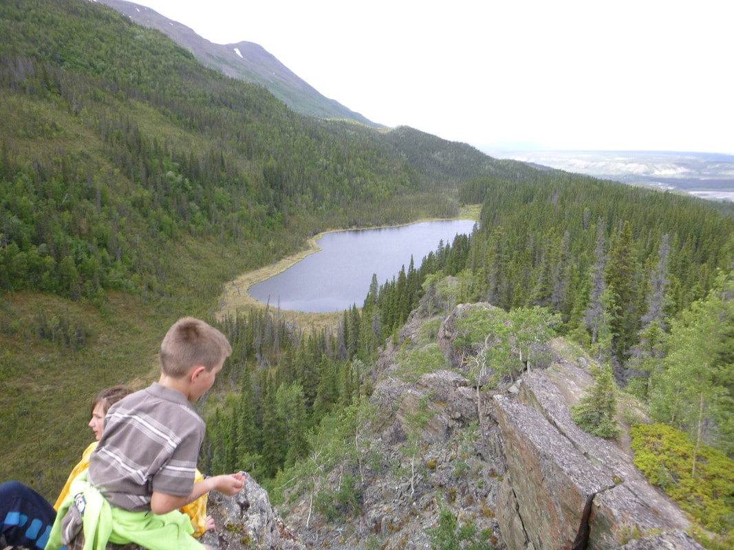 Just beyond the “official” end of the Liberty Falls trail, this little lake beckons on a hot day. WISE photo
0 Comments
Leave a Reply. |

Who We AreWISEfriends are several writers connected with Wrangell Institute for Science and Environment, a nonprofit organization located in Alaska's Copper River Valley. Most of these articles originally appeared in our local newspaper, the Copper River Record. Archives
August 2021
Categories
All
|
 RSS Feed

|
WISE is a
501(c)3 nonprofit organization |
Contact Us |